Here's something to perplex the tourists amid the slew of London-themed paraphernalia emerging this summer. Graphic designer Melissa Price has produced a set of two maps of the city; but instead of featuring its streets, the focus is on its underlying geographic features.
Price, who works for graphic design consultants, Cartlidge Levene, has stripped back the built environment to reveal the lie of the land beneath, showing how the Thames and its tributaries have shaped the city's topography.
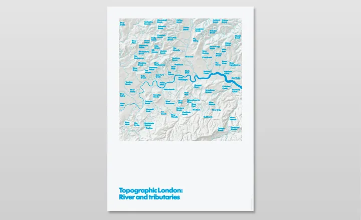
Based on Ordnance Survey's DTM (Digital Terrain Model) dataset, the River and tributaries poster shows the small rivers, streams and brooks that feed into the Thames as it snakes its way through London. Many of these are now trapped under ground or have been channelled into the sewer system.
The Hills and valleys poster, meanwhile, shows how London neighbourhoods have taken their names from their geographic location, such as Kensal Rise and Muswell Hill.
Price's alternative portraits of the city come screen-printed in metallic silver with blue and green on GF Smith Naturalis Absolute Matt White 160gsm paper.

Names such as River Westbourne and Wembley Brook reveal the origin of the names of some of London's well-known neighbourhoods

The Hills and valleys poster maps out the ridges, hills and valleys created by the tributaries

Some of the names are so familiar in Londoners' minds that the geographic reason behind them has been almost forgotten

The posters come screen-printed in metallic silver with blue and green on GF Smith Naturalis Absolute Matt White 160gsm paper